Take a step into nature: Illinois hikes
April 4, 2023
Starved Rock State Park offers views, indigenous history
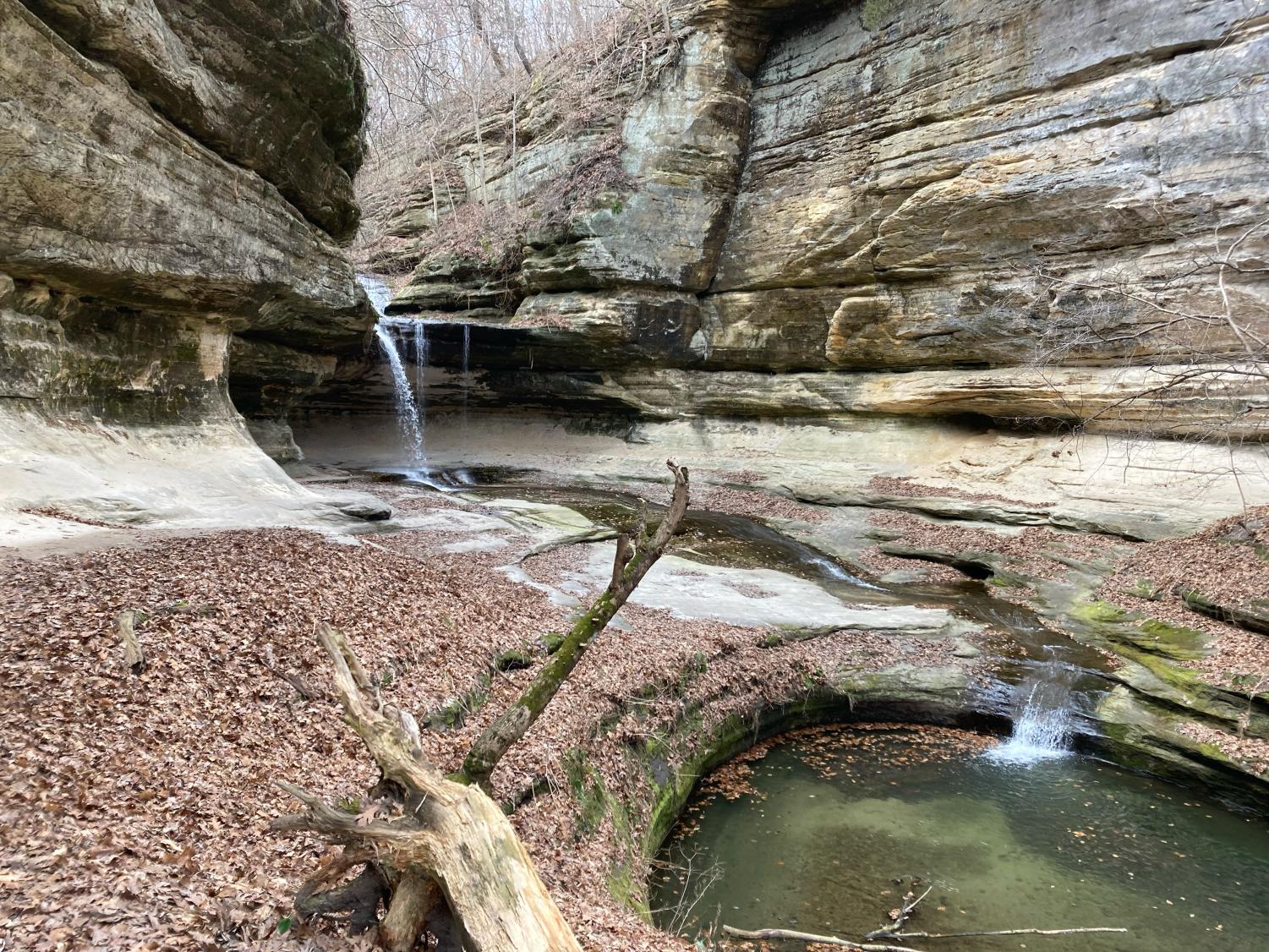
Layered sandstone cliffs covered in moss and lichen are split by a stories-high waterfall tumbling down into a stream, which meanders its way through a forest of oak, maple and aspen trees toward the sandy banks of the Illinois River. This scene is almost commonplace in Starved Rock State Park, which abounds with spectacular cliffs, bluffs, waterfalls and other geologic formations practically unseen in Illinois, famous for its flatness.
Even in the early spring, Starved Rock State Park is a fantastic place for any length or difficulty of hike. Trails offer views and sights special enough to make it worth the significant, nearly two-hour drive from Chicago to Oglesby.
The park’s namesake landmark, Starved Rock, is only a few minutes’ hike from parking via a paved trail. The trails leading up and around the almost sheer bluffs which make up the landmark are dotted with signs explaining the area’s rich pre-colonial Native American history. According to partially substantiated legend, this was the site of the downfall of the Illinois Confederation of Native Americans, who, fleeing from several other tribes, had no choice but to climb the cliffs of Starved Rock and defend themselves. A battle eventually turned into a siege, and the Illinois Confederation slowly starved. Whether that particular story is true, the area, like many others in Illinois, is full of history describing the Native Americans’ growing desperation and hardship as European settlers encroached on their land and massacred their people.
The view from the top of Starved Rock, if somewhat eerie, will be refreshing for most Chicagoans: forest, sliced by the wide Illinois River, stretches out in every direction, an expansive amount of horizon. Walk the trails on top of it, and you’ll also be able to see the breathtaking, river-facing side of the bluffs, which meet the river like a 40-foot wall.
While Starved Rock itself has some stunning scenery, it’s only the beginning of what the park has to offer. Several miles of trails, fairly well-maintained even in the early spring, follow the river upstream, providing a scenic mixture of riverside views and deciduous forest. While the forest doesn’t become lush until the late spring, the lack of leaves makes the beautiful geology more visible. The highlights here are the waterfalls, which flow in full force during the middle of spring and are always spectacular to witness. If you plan on going, the falls in Wildcat Canyon (two miles round trip) and LaSalle Canyon (four miles round trip) are some of the best, having carved the sandstone over which they flow into nearly alien rock formations.
The Starved Rock Lodge website touts the park as “a world apart from anything else in Illinois!” While this is arguably true, it’s worth mentioning that it doesn’t have a lot of competition. Hikers expecting the postcard-level beauty more abundant in other places of the country might be somewhat disappointed. The park is pleasant, often beautiful, but not necessarily awe-inspiring.
However, Starved Rock State Park doesn’t really need to be awe-inspiring to be worth a trip. It almost feels like a theme park stuffed full of geology, water, views and history, coaxing you longer and longer along its peaceful trails until you can hardly imagine you’re just a few hours away from the city.
Reconnect at nearby, leisurely Palos Heights
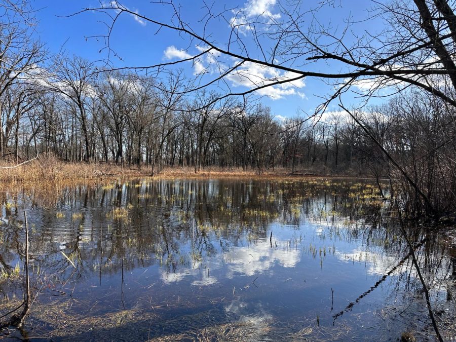
A picturesque lake in the Palos Heights trail system is surrounded by a budding forest. The peaceful trails are only 21 miles.
The sunlight filters through the sparse pine trees, illuminating the golden brown leaves covering the forest floor. A robin stands on a pile of leaves, rummaging for a twig for its nest, while frogs croak non-stop in a nearby marsh. The tranquil sounds and sights of nature transport you to a world away from the buzz of the city.
Located just a 30-minute drive southwest from downtown Chicago, the Palos Heights trail system in the Forest Preserves of Cook County offers dozens of miles of trails for a refreshing morning walk or afternoon stroll. Visitors can take leisurely walks on paved paths, hike through the forests or bring mountain bikes to explore the trails.
The trail system is filled with rolling hills, deep ravines and beautiful views to take in the beautiful oak forests. Lakes and marshes also line the trails.
Before leaving, make sure to examine the online trail map to help pick the length and type of trail. It also clearly indicates parking lots and trail entrances to help find directions. Many trail sights also have their own picnic grove, so consider bringing lunch or a snack to eat while enjoying the nature.
The Swallow Cliff Woods offer an enjoyable hike and quite a picturesque view. Enter from the north side to find a 100-foot bluff that provides a demanding stair workout. The uneven granite steps provide a hefty challenge to climb, but the lookout observatory at the top provides a beautiful view of the forest preserve and even a glimpse of the city skyline on the clearest of days. A café at the bottom of the stairs can provide a quick snack or smoothie treat.
Beyond the stairs lies a network of trails for a peaceful walk in the forest. Pine trees line the path and off-the-beaten path trails go into rolling streams at the bottom of hills or prairie grasslands. Birds chirping, squirrels fluttering and frogs croaking supplement the peaceful walk in the fresh air. The 8.1-mile Yellow Unpaved Loop winds around Swallow Cliff Woods and connects to the ravine-filled Cap Sauers Holding Nature Preserve and Calumet-Sag Trail along the channel.
As the spring season comes, the Palos Heights trail system will come to life out of its winter slumber with more wildlife and budding trees. Consider taking a casual stroll as the weather gets warmer to regain a peaceful touch with nature.
Tips to get the most out of your hike
Who doesn’t want to make the most of their hiking experience? Knowing what to bring and how to prepare for a day, or even overnight, trip will help ensure an enjoyable and refreshing time outdoors.
When planning a trail, be aware of its length, difficulty and your own abilities. Having a park map is especially helpful for gauging distances and orienting yourself in the grounds.
Check the weather forecast before hiking and prepare for changes in weather.
If hiking solo, inform someone beforehand that you are hiking and where you are going. Having a means of communication on hand is crucial.
Bring essentials:
• Food and water are necessities to prevent dehydration and, in hot temperatures, heat exhaustion and stroke. Some parks may not have clean and accessible water sources
• Other very useful items that are recommended are a hiking backpack, first-aid supplies, a repair kit, sunscreen and insect repellent.
Information about overnight hiking can be found on a park’s website.